Monday, September 2, 2013

Wildflower Meadow

Thursday, Aug. 22, 2013.  Hazel and I meet up with my brother Ted in a very secluded spot in the Rio Grande National Forest in Southern Colorado. We set up camp at 10,500 ft. elevation in a meadow that is about the size of 10 football fields.  We've nicknamed it Wildflower Meadow because when we discovered it the wildflowers were so thick they covered it like a carpet. This picture can't do it justice but it gives an idea of how many kinds there were.
I always seem to take pictures of bluebells because they are one of my favorite wildflowers.

This butterfly likes the wildflowers too.

There not only were a lot of wildflowers but a lot of mushrooms too like this one that was the size of a softball.
The view from camp was spectacular, one morning we watched 2 mule deer with huge racks graze in this field and the next morning in this same place were 2 big elk.
At evening the same scene takes on a whole different look as a rainbow lights up.
As we hike around the area we find the remains of an old stable. Maybe a hunter kept his horses here while hunting elk.
Back at camp I set up my telescope hoping that night will bring clear skies.  At 10,500 ft. and no light pollution the viewing could be awesome.
It turns out to be a great night for star gazing.  We saw Venus which was very bright.  Then we saw Saturn and its rings and even its moon Hyperion.  Next we looked at M8 which is the Lagoon Nebula where baby stars are forming.  Then we saw M5, a globular cluster of almost a million stars that astronomers estimate to be 13 billion years old.  Finally we look at M31, The Andromeda Galaxy.  It contains 300 billion stars and is much larger than our Milky Way Galaxy.  M5, M8 and M31 are all part of the 110 Messier objects. From 1774 to 1781 the astronomer Charles Messier was the first to catalog these deep sky objects and I hope to see all of them with my telescope.
On Sat. we decide to hike a section of the Continental Divide Trail.  The continental divide runs through Mexico up through the U.S. and Canadian rocky mountains on to the Arctic Ocean. It is called the continental divide because all of the rivers on its west side drain into the Pacific Ocean and those on its east side drain into the Atlantic Ocean.
While we are getting our packs ready we hear a loud train whistle and look up just in time to see the Cumbres and Toltec Steam Train pass overhead.
At first the Continental Divide Trail doesn't look much different than any other trail.
Before long we are looking down on the railroad tracks we were standing under and the scenery is fantastic.
After about 3 miles we come to a very nice waterfall where we decide to take a break.
After resting we turn around and head back.  The four days of camping, hiking and star gazing was so much fun I decide to take a group picture of Grandpa Tom, brother Ted and Hazel Doggie.

Sunday, November 4, 2012

Antelope Island, Great Salt Lake

Saturday, Oct. 27, 2012.  Suzanne and I and the doggies drive out on the causeway to Antelope Island on the Great Salt Lake. We would spend the next 3 days camping and hiking. Antelope Island was discovered in 1845 by explorers John C. Fremont and Kit Carson who is an ancestor of my grandchildren, Maddie, Izzy, Ben and Nate. While exploring Kit Carson shot a pronghorn antelope and named the island for it out of gratitude.
Antelope Island is 18 miles long and 4 miles wide.
The Great Salt Lake looks like any other lake except that it is 8 times saltier than the oceans and therefore no fish can live in it. Here's the view from our campsite looking east across the lake to the Wasatch Mountains.
Even though there are no fish in the Great Salt Lake there are brine shrimp which the sea gulls and waterfowl eat. The island is home to Pronghorn Antelope, Mule Deer, Big Horn Sheep, Coyotes and Bison.  Here are a couple of the Mule Deer that we saw.
The biggest animals that we saw were the American Bison. I learned that they are not really Buffalo like most people call them but regardless, they were huge and scary.
This herd decided to graze only about 100 ft. from our camp.
This guy got a little too close for my liking.
On our last night the sunset was spectacular.  From our camp it looked like the sky had set the Great Salt Lake on fire.

Sunday, October 7, 2012

Conejos River, Colorado

Friday, Sep. 14, 2012. I drove up into south central Colorado to the South San Juan Wilderness for 3 days of camping and hiking with my brother Ted.  We set up camp along the shores of the Conejos river.  Not far from here is were the last Grizzly Bear was killed in Colorado.  There have been several unconfirmed sightings since then. Hopefully we won't have an encounter with one.
Just a short walk from our camp is an excellent place for bird watching. One of my favorite birds, the American Dipper, hung around all weekend.  We also saw Belted Kingfishers, Common Mergansers, Blue Winged Teals, Magpies, Red Tailed Hawks, Stellers Jays, Red Shafted Flickers and a Rough Legged Hawk.
On Saturday we started hiking up this trail with Duck Lake as our destination.  It would be 3 1/2 miles one way with an elevation gain of more than 1,100 ft. to 10,200 ft.
Along the way we would pass many meadows like this one.
This mountain would be to the south for the first half of the hike.
There would be several ponds to sit beside while taking a break. I liked this one because of the green water.
Another mile up the trail we came to this pond and the scenery around it was spectacular.
Just over the next ridge we reached our destination, Duck Lake.
It had been such a tough hike that I was exhausted so I took off my pack and relaxed on the shore near a beaver hut.
After relaxing we hiked the 3 1/2 miles back and it was much easier going down the mountain.

Friday, September 28, 2012

Rio Santa Barbara

Sunday, August 19, 2012.  Today I would hike up the Rio Santa Barbara.  It's a river that flows through the northern part of the Pecos Wilderness in the Sangre de Cristo Mountains which are part of the Rocky Mountains.  My hike would start at 8,800 ft elevation and I would reach about 9,900 ft. and the total hike would be 11 miles.
Here's a picture of the trailhead.
For the first couple miles the trail stays close to the river.
The trail climbs up above the river and I can look down and see a fly fisherman trying to catch a brook trout.
Back on the trail I continue my gentle ascent.
I come to an opening and stop to admire the views of the mountains.  When Maddie comes to visit for spring break Suzanne and I would like to take her on her first backpacking trip and camp out at this spot.
Back on the trail I see a local rancher riding his horse.
A chipmunk checks me out as I hike by. Probably hoping I'll drop something to eat.
Bluebells are always worth a picture.
Back on the trail the views are spectacular.
What a wonderful day for a hike.
Finally, Chimayosos Mountain comes into view.
I just can't help looking around and admiring nature.
In order to get back to my truck I must cross this 30 ft. bridge.
Once I get across I have a decision to make. Yogi Berra once said "if you come to a fork in the road (trail), take it" so I did.
This nodding sunflower spoke my name.
Back on the trail with only one more mile to go.
These Aspens were just too picturesque to pass up.
And that brings me to the end of my hike along the Rio Santa Barbara.

Sunday, June 3, 2012

Best Friends

Memorial Weekend, May 25-28, 2012.  The title "Best Friends" has multiple meanings in this post.  I would be camping and hiking this long holiday weekend with my best friend of 10+ years, Suzanne and Hazel Doggie would be camping and hiking with her best friend Dooley.  Together the four of us would be camping near, and hiking through, the Best Friends Animal Sanctuary near Kanab, Utah.  It is "the nation's largest no-kill safe haven for displaced, homeless or unwanted domestic animals." It's where the TV show "Dog Town" was filmed. Please take a few minutes to check out their web site at    http://www.bestfriends.org/index.htm
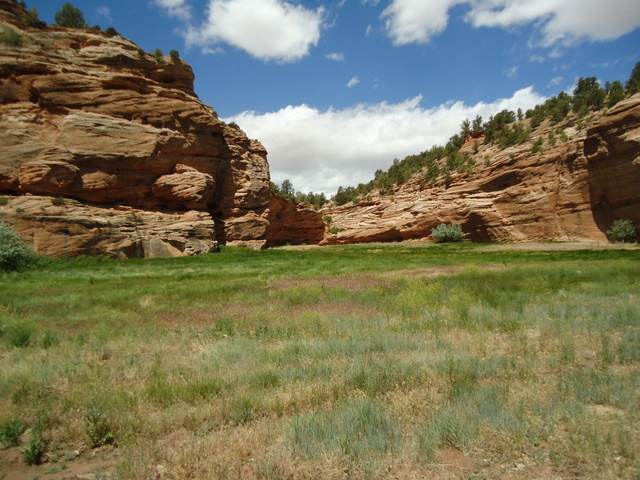
The sanctuary is over 3,000 acres dedicated to the well being and rehabilitation of dogs, cats, horses and many other unwanted animals.  Once the animals are ready they are adopted out to qualifying people.  The people who work there are very dedicated and many of them are volunteers who spend their vacations helping in any way they can.  The sanctuary also leases the surrounding 30,000  acres from the Federal government to insure that no development takes place and to provide additional wilderness for wild animals to be safe in.  This is the view from the main parking lot and you can see how wild it is kept.
There are a lot of trails throughout the property for hiking and all dogs are walked on them twice a day by the volunteers.  Suzanne and Dooley are walking along a two tracker on our way back to my truck after hiking down to the river.
Also on the sanctuary property is a huge pet burial plot called Angels Rest where thousands of pets were laid to rest.  There are lots of chimes hanging in it and the music they constantly play is beautiful.
We spent a whole day touring and hiking and petting.  We plan on spending a week or two volunteering as soon as it can be arranged.  Not far away Suzanne is getting the tent ready.  The wind was making it difficult by somehow we managed.
The views in Southwestern Utah are spectacular.
The rock formations have some strange shapes.
The colors and lines make them picture worthy.
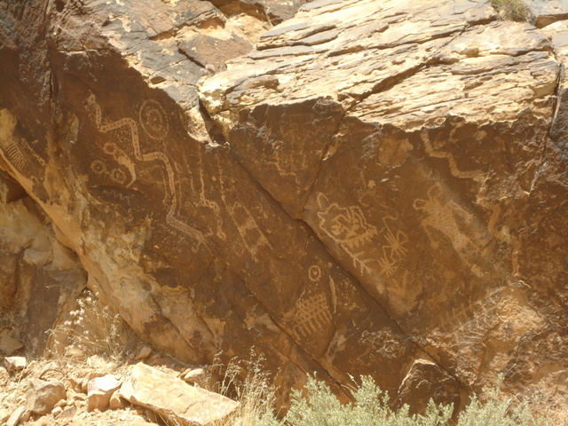
Next we go hiking at the Parowan Gap Petroglyphs near Little Salt Lake.  Petroglyphs are etchings in rock that native people made to commemorate events or to represent calendars or for a variety of reasons.
Here are some of the ones we saw at Parowan Gap.
Here you can see some strange looking people and snakes and many mysterious things.
Next we went on a four mile hike through the desert mostly to give the doggies some much needed exercise.  Afterwards we commemorated our "Best Friends" adventure with this group picture before heading home.